|
|
 |
|
|
|
|
|
 |
|
|
|
|

|
| Population |
379,196
(as of July 2005) |
| No.
of Households |
138,901
(as of October 2004) |
| Area |
633.75
km2 |
| Location |
Latitude
34°45’58”N, Longitude 137°23’41”E |
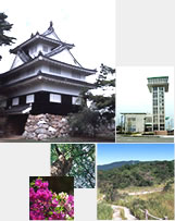
| City
Symbols Flower |
Azalea |
| City
SymbolsTree |
Cinnamon |
|
The City of Toyohashi is located
on the south-eastern tip of Aichi Prefecture.
It is a historic city located approximately
midway between Tokyo and Osaka and borders
Shizuoka Prefecture to the east and the Pacific
Ocean to the south.
People (the Ushikawa tribe) first inhabited
this region almost 100,000 years ago. The
historic remains of Urigo, located within
the city, are an impressive display of hunting
and farming tools that have been excavated
from the area. A range of other implements
from the area indicate that certain villages
existed here during the early to late Yayoi
era.
The area has long been referred to as Hono
Kuni, however during the Taika reforms of
646, the area was unified with the Mikawa
Kuni region. During the Kamakura period, a
bridge called Imahashi was constructed over
the Toyogawa River, and the area soon became
referred to as Imahashi.
In 1505, the head of the powerful local family
Kohaku Makino ordered the construction of
Imahashi castle on the banks of Toyogawa River.
In 1546 the castle was handed over to Yoshimoto
Imagawa, who promptly renamed the area Yoshida.
The area was a bustling castle-town under
the rule of many lords during the Edo period,
and also served as an important rest stop
on the Edo to Kyoto highway.
The town of Yoshida was renamed to Toyohashi
in 1869 after the Toyohashi Bridge that was
constructed to span the Toyogawa River. Official
town administration began in 1889 and in 1906,
the neighboring villages of Hanada and Toyooka
were merged to form the Toyohashi City administration.
The silk and textile industry was booming
at the time, with smoke from factories in
the Hanada district enveloping the city. In
1908 the 15th Division of the Japanese Imperial
Army set up camp in the city. However the
start of the Pacific War saw most of the area
destroyed during the air raid of June 20,
1945.
Impressive town planning during the post-war
reconstruction saw the construction of wide
streets and spots of greenery around the city.
Schools were built on the sites of military
facilities, and 1955 saw the merging of 5
neighboring villages. The current land area
is close to 260km2 and the total population
is over 376,000. Toyohashi was designated
a major core city in April 2000.
Taken
from the Toyohashi Yearbook,
Commerce and Industry in Toyohashi
|
|
|
|
|
|
|